My personal connection to the Western Front.
After the death of my parents, I inherited the World War I diary of my grandfather, Conrad Hasselbacher. I had not previously known of its existence. He kept it during the opening five weeks of the war, from mobilization on August 1, 1914, until he was wounded the next month. I also inherited a number of wartime photographs that I was able to place in the timeline. These are fascinating primary historical documents that foreshadow the story of "All's Quiet on the Western Front. " In the first 5 weeks weeks of the war he transitions from the experience of the "Hurrahs" of mobilization to the battlefield acknowledgment, "that it takes a lot of blood to defeat the enemy." In both language and penmanship is demonstrated both the intense anxiety of conflict interspersed with the boredom of waiting. Conrad was probably one of the first soldiers ever to be injured by an aerial attack. Fortunately for my future existence, that injury spared him further active combat.
One of my fantasies has been to retrace Papa's steps from mobilization from the training facility at Grafenwöhr, to the front lines of Lorraine/Lothringen where he was bombed with a fleschcette. I never dreamed that I would accumulate enough military information to make the attempt, but now I can. How I came to this place will be a story for another setting!
One of the obstacles to that enterprise was having a good contemporary map. Some of the villages in the war-zone ceased to exist. Additionally, I never knew whether I should be looking for French or German place-names. With the magic of the internet and Ancestry.com, I was able to find the military records of my grandfather which identified some of the places where he served, where he was wounded and treated, and some of his subsequent activities.
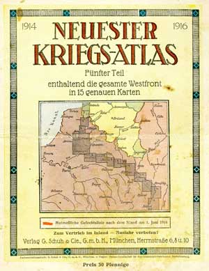
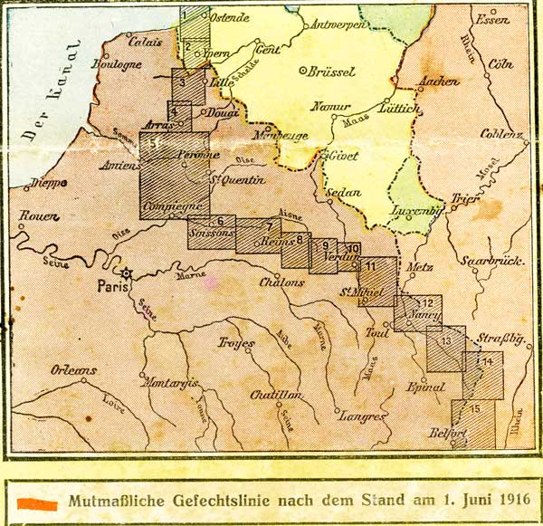
During my most recent trip to Germany, I was able, purely by accident, to acquire detailed maps of both the Western and Eastern fronts of WWI in Europe as of June 1916. These have already been of assistance as I reconstruct the path of Conrad's regiment. Because I believe they will be of interest to others, I duplicated them and present them here. I have little idea about what residual copyright protections may still be relevant. I give full credit to the original publisher and make these treasures available to other interested individuals. I will begin with the Western Front, and will present the Eastern Front later (sooner if someone tells me they have a specific interest)! If a higher resolution map is desired, please contact me and tell me of your interest, and I will try to accommodate your needs.
Just below is an index map from the cover of the atlas. Click over the area of interest and the designated map will appear in a new window.
Addendum: Your advice requested.
In the past, I prepared images on this site to be a maximum of 1000 pixels wide. I began this practice in 2007 assuming that some viewers would still be using older monitors or laptops with limited screen resolution, or for those with slow internet. I wanted the entire image to fit a screen without having to scroll and yet be large enough to read original church documents on-screen. Is this still a necessary and reasonable strategy? My smallest Apple MacBook Air has room to burn.
I cheated a little for the military maps above as I made the horizontal maps 1100 pixels wide. Even as a result of this practice, some of the maps seem crowded. I would like to hear from you, especially those of you with knowledge of internet best-practices, about what I should do in the future. How should I handle the tradeoffs of file-size, resolution, different monitors, and download speeds?
I have not given much thought at all about how to handle the smaller screens of portable devices. I barely have the technological skills to prepare a internet page for a desktop machine!
Thanks,
Peter